
價格:免費
更新日期:2019-03-01
檔案大小:58.2 MB
目前版本:1.6
版本需求:需要 iOS 9.0 或以上版本。與 iPhone、iPad 及 iPod touch 相容。
支援語言:英語

Get turn by turn directions to any LSD in Alberta, BC, Saskatchewan, or Manitoba with this simple to use app.
Find location, get turn-by-turn directions, AS WELL AS view well data, weather forecasts, drop pins to see location name, and share well info and location with OilTrails. The only app that combines all these features with a simple yet powerful interface.
This multifunctional lease locator app makes getting to work a breeze. Simply enter the legal land description to view the surface location OR drop a pin on the map to view LSD and well info (if vertical). The location can be opened in Apple or Google maps for turn by turn navigation. Change the origin location to see step-by-step directions to location from the nearest town, useful for putting together ERPs or provide visitors directions.
No cell service? No problem. As long as turn by turn navigation is started before service is lost, the directions will continue to function so you don't have to worry about being stranded half way to location.
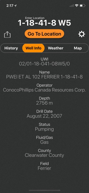
Enter downhole location and view well information such as the operating company, depth, drill date, current status, downhole fluid, formation of wells on record in Alberta.
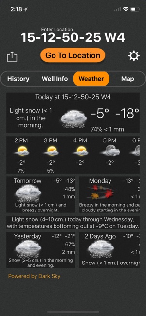
See the current, future AND past weather specific to the location entered. Wondering if the lease is too wet or has snow to be cleared? View the precipitation the location was forecasted to receive in the past three days. Scroll for 48 hrs of hourly forecasts, 7 daily forecasts, and previous forecasts.
Drop a pin on the map to see the LSD and well info (if the well is vertical) for that location.
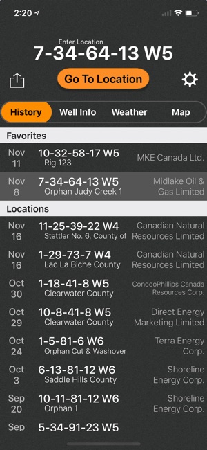
View history of past locations viewed and date they were looked up. Makes driving logs and reports a breeze by knowing where and when you were. iCloud support syncs history between compatible devices and creates a backup.
TLDR
-Open locations in Apple or Google maps for turn-by-turn navigation
-Enter downhole location to view well info such as the operating company, depth, drill date, current status, -downhole fluid
-View the current weather at location as well as hourly and daily forecast AND previous forecasts to see if the location has received rain/snow is the past three days
-See location in app and view with standard, hybrid, or satellite imagery
-Store history of previously viewed wells/locations
-Share location and well info via message, email, twitter, and more
-Drop pins on the map to see that location's LSD and well info
*Google Maps app must be installed separately to open up locations with it
*Downhole well data currently available for Alberta and BC. Saskatchewan and Manitoba will be coming soon

*Previous weather is based on previous forecasts, not what the location actually received
支援平台:iPhone, iPad, iMessage